Bakar bay
Naziv
Bakar bay
Kategorija
06 Cultural landscape
Klasifikacija prema RKD
Cultural landscape
Vrsta baštine
Immovable cultural property
Grad
Bakar
Opis
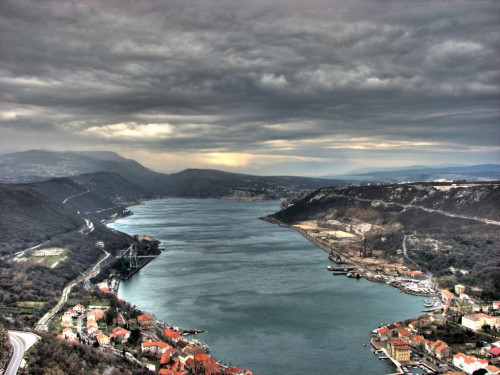
Bakar Bay is an interesting geological formation, a submerged part of a karst valley that stretches parallel to the coast in a northwest-southeast direction. The largest bay in the Croatian Littoral, it is 4.6 km long, up to 1.1 km wide and up to 44 m deep. Because of the protected position of the bay, Bakar became an important maritime centre, especially after the construction of the Karolina Road (1726-1732) connecting Karlovac in the interior with the coast. The town experienced its heyday in the 18th century when the Empress Maria Theresa declared it a free port in 1778, after which it received the status of a free royal town with municipal self-government and a statute in 1779. After stagnating under French administration (1809-1813), seafaring began to develop again in 1822, when Bakar came under the rule of the Croatian ban (viceroy). In 1849, the State Public Nautical School (today’s Bakar Maritime School) was founded; in 1856, local shipowners had 22 sailing ships; in 1875, the Croatian Shipping Company was founded with the ships the Ban Mažuranić, Hrvat and Bakran; in 1878, the first steamer the Grad Bakar was purchased for coastal navigation between Bakar and Rijeka, and the Steamship Company was founded. Two symbols of Bakar attest to the area’s maritime and fishing traditions: the tunera and baškot. A tunera is a high wooden ladder with a lookout post for observing the arrivals of shoals of tuna. Some of these structures have today been restored in the bay to commemorate this traditional way of fishing that was practised here until the mid-20th century. Baškot is a type of ring-shaped sea biscuit that was brought to Bakar by fishermen from Chioggia. In the past, sailors would take it instead of bread on longer voyages because it could last up to six months due to its dryness, and would dip it in red wine, tea or coffee with milk. The Bakar baškot won a gold medal for quality in 1919 in Paris, as evidenced by a plaque on the wall of the local Baškotarna bakery, where this sea biscuit is produced. Today, baškot is the official souvenir of Bakar.
Valorizacija
Bakar Bay with steep and high shores is deeply indented into the coastal mainland. The bay is entered through the Bakar Strait, which stretches for 1.5 km with a width of 300 m. The Bakar Bay stretches in the northwest-southeast direction for 4.5 km and is 1 km wide on average. On the east side of the entrance to Bakar Strait there is the port of Kraljevica. The old town of Bakar is in the northwestern part of the bay with the port of Bakar. In the southeastern part of the bay there is the port of Bakarac. Along the northeast side of the bay there are numerous sources of fresh water and therefore the sea in the bay is less dense and colder. The area of the Bakar Bay is known for the storm surges of the bora, which in the winter months causes difficulties in transport, both by land and sea. Within the bay there are several terminals and harbours for smaller vessels. The petroleum port Bakar (Borići) is located on the northwest coast of the bay and is intended for the reception of oil tankers. The Goranin terminal for the reception of RO-RO ships and general cargo ships continues to the petroleum port in the northwest direction. The Podbok terminal is located on the northeast side of the bay and is intended for the reception of bulk carriers. Northwest of the Podbok terminal there is the Masaryk wharf intended for passenger transport. At the foot of the town of Bakar there is the port of Portić, with boats moored along the constructed coast of the entire bay. In the southeastern part of the bay there is the village Bakarac with a port for mooring smaller vessels. Bakar Bay is also famous for tuneras, which were more numerous in the past.